Шрифт
Цвет
Графика
Изображение точки

To see AR mode in action:

1. Install ARTEFACT app for iOS or Android;

2. Find the exhibition «Exhibition of Lenin House-Museum»

3. Push the «Augmented reality» button and point your phone's camera at the exhibit;

Скрыть точки интересаПоказать точки интереса
Показать в высоком качестве

World Hemisphere Map

Creation period
late 19th century
Place of сreation
St. Petersburg, Russia
Dimensions
85,5x158 cm
Technique
typographic printing
Collection
4
Open in app
#1
Alexey Ilyin’s Cartographic Establishment
World Hemisphere Map
 
0
 Advanced issues found
 
#2
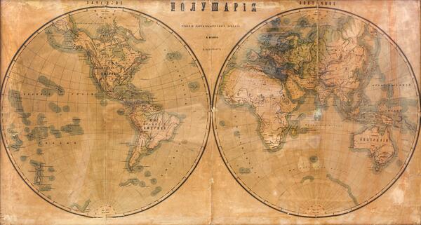
There is a small-scale World Hemisphere Map on the wall in Vladimir Ulyanov’s room, published and printed in the late 19th century by the Cartographic Establishment of Alexey Afinogenovich Ilyin in St. Petersburg. In the 1880s this shop produced almost 90% of all maps used in the Russian Empire. The founder’s son, Alexey Ilyin, personally compiled and edited maps and educational atlases. All in all, the company employed more than 30 engravers, 20 printers, and 60 handymen. In addition to maps, they printed city plans, blueprints, labels, patterns, commendation sheets, etc.

The map in the exhibition depicts continents, oceans, plains, and mountains in yellow, brown, and blue. In addition to physical geographic features, the engraver also mapped states, colonial territories, and other lands within boundaries according to the political situation of the second half of the 19th century.
#7
Part of the map
#8
The map shows virtually no borders of the countries of the African continent, as the main events related to the redivision of Africa would happen only in the 20th century. But it already marked the majority of islands in the Pacific Ocean — the Hawaii, the Marshall Islands, the Tuamotu Archipelago, known as the Russians’ Islands (in 1820, traveler Faddei Bellingshausen named some of the atolls after the eminent Russians), and others.

There are parallels marked on the map, not typical for modern maps — Tropic of Capricorn and Tropic of Cancer. On modern maps, they are indicated as the southern and northern tropics, respectively. These are the southernmost and northernmost latitudes at which the sun may rise to its zenith at noon. The tropics are shown approximately, as their exact location depends on the tilt of the planet’s axis of rotation relative to the Sun.

The World Hemisphere Map in terms of the contours of the continents and oceans is virtually modern ones, indicating the high geographical culture and scientific development of the second half of the 19th century. The northern boundary of the southernmost polar continent, Antarctica, is missing. As a continent it was discovered on January 28, 1820 by the Russian expedition of Faddei Bellingshausen, but its exact boundaries were being clarified by geographers until the beginning of the 20th century.
#9
Antarctica with incomplete boundaries
#6
read morehide
00:00
00:00
1x

World Hemisphere Map

Creation period
late 19th century
Place of сreation
St. Petersburg, Russia
Dimensions
85,5x158 cm
Technique
typographic printing
Collection
4
Point your smartphone camera to open in the app
Share
VkontakteOdnoklassnikiTelegram
Share on my website
Copy linkCopied
Copy
Open in app
To see AR mode in action:
  1. Install ARTEFACT app for 
  2. iOS or Android;
  3. Find and download the «Paintings in Details» exhibition
  4. Push the «Augmented reality» button and point your phone's camera at the painting;
  5. Watch what happens on your phone screen whilst you flip through the pictures.
 
We use Cookies
Cookies on the Artefact Website. We use cookies to ensure that we give you the best experience on our website. If you continue without changing your settings, we'll assume that you are happy to receive all cookies on the Artefact website. However, if you would like to, you can change your cookie settings at any time.
Подробнее об использованииСкрыть
Content is available only in Russian

Ошибка на сайте

X

Нашли опечатку?...

%title%%type%