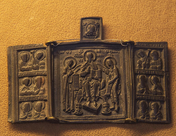
A skladen is a small folding icon of two or three — less often four or five — panels. In the early days, skladens were made to be worn on the body, but in time there also appeared those in icon-cases, for home use, for processions, and for travel. Typically, such icons were made of wood or cast in brass, copper, or bronze, and then the image was forged or pressed onto them, sometimes covered with enamel. In the 18th–20th centuries, travel icons became particularly popular.
The original icon from the museum’s Auxiliary Research Fund was discovered in 1973 by the “Komsomolskaya Pravda” expedition led by Dmitry Igorevich Shparo. It is among the finds associated with the expedition of Eduard Vasilievich Toll.
The Russian geologist Eduard Toll was convinced of the existence of Sannikov Land — the coast of the polar continent of Arctica. It was reported in 1810 by the traveler and trapper Yakov Sannikov, but due to the inaccessibility of the location, no one was able to get there.
In 1886, Toll took part in the expedition of the Academy of Sciences led by Alexander Alexandrovich von Bunge, aimed at exploring the Novosibirsk Islands. During the expedition Toll noticed the outlines of a ghost land. The new Russian polar expedition, organized by Toll on the schooner Zarya, was to continue the exploration of the Novosibirsk islands, as well as find Sannikov Land and reach the Pacific Ocean following the Northern Sea Route. Among the participants were the hydrographer Alexander Vasilyevich Kolchak and the boatswain Nikifor Alekseyevich Begichev.
During the 1900–1902 wintering seasons, the western coast of Taimyr was surveyed and over 250 new place names were mapped.
In May 1902, Eduard Toll, the astronomer Friedrich Seeberg and the fur trappers Nikolay Dyakonov and Vasily Gorokhov traveled by dog sled and then canoe to Bennett Island, then left the island in November to reach the mysterious land but were never heard from again.
The Zarya was the first vessel in history to reach in free sailing 77°32’ north latitude at the boundary of the Laptev Sea and the East Siberian Sea.
Later attempts to find Sannikov Land, including those made by the Sadko icebreaker crew (1937) and by Arctic aviation, yielded no results. Perhaps it was an ice island. The underwater bank discovered at the specified location was named Sannikov Land.
The locations named after Eduard Toll include a strait in the Kara Sea and a research hydrographic vessel.