In Kievan Rus, Gorokhovets was one of the small towns that were located on the eastern borders of the Grand Duchy of Vladimir on the banks of the Klyazma River. It was a fortified settlement, that included a posad — the territory of townspeople, merchants, and craftsmen — and a burial ground, both of them were located outside the fortifications.
For a long time, the town was underexplored: archaeological research in that area was mostly sporadic. The site was overlooked and thus not included in major projects that were aimed at studying the towns of the Grand Duchy of Vladimir.
The central place in the stratigraphy of the medieval Gorokhovets was occupied by the settlement on the right bank of the Klyazma, composed of bedrock. It was located in the western part of the present-day town on the site of the headland, formed by an extensive ravine system. The height of the headland varies from 40 to 50 meters above the river.
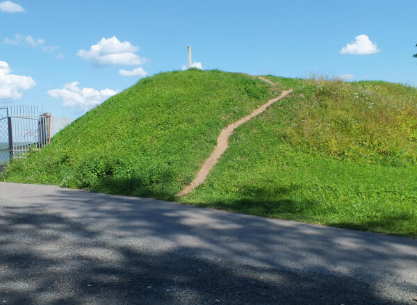
Ruined fortifications have been preserved in the southeastern part of the settlement. They are represented by a 5-meter-high earth rampart. The length of the preserved part of the rampart is about 94 meters, and the base width reaches 22 meters. The fortifications are demonstrated in the photograph on display.
A portion of the remains of fortifications was found along the southwestern and western sides of the settlement site. Topographically, they are represented by a semicircular earth rampart up to 1 meter high, with a brick monastery fence on top of it.
There are no traces of fortifications on the northern side. However, according to the materials of the archaeologist Valentin Vasilyevich Sedov, who led excavations there in the 1950s, the remains of the earth rampart were still discernible in the mid-18th century. This means that the settlement most likely had fortifications along its entire perimeter.
In the southeastern part, in front of the surviving fortifications are the remains of a moat, which lead to two converging ravines. Their upper parts have a flat area in between them.
The total area of the settlement, including the preserved fortifications, is about 2.2 hectares.
For a long time, the town was underexplored: archaeological research in that area was mostly sporadic. The site was overlooked and thus not included in major projects that were aimed at studying the towns of the Grand Duchy of Vladimir.
The central place in the stratigraphy of the medieval Gorokhovets was occupied by the settlement on the right bank of the Klyazma, composed of bedrock. It was located in the western part of the present-day town on the site of the headland, formed by an extensive ravine system. The height of the headland varies from 40 to 50 meters above the river.
Ruined fortifications have been preserved in the southeastern part of the settlement. They are represented by a 5-meter-high earth rampart. The length of the preserved part of the rampart is about 94 meters, and the base width reaches 22 meters. The fortifications are demonstrated in the photograph on display.
A portion of the remains of fortifications was found along the southwestern and western sides of the settlement site. Topographically, they are represented by a semicircular earth rampart up to 1 meter high, with a brick monastery fence on top of it.
There are no traces of fortifications on the northern side. However, according to the materials of the archaeologist Valentin Vasilyevich Sedov, who led excavations there in the 1950s, the remains of the earth rampart were still discernible in the mid-18th century. This means that the settlement most likely had fortifications along its entire perimeter.
In the southeastern part, in front of the surviving fortifications are the remains of a moat, which lead to two converging ravines. Their upper parts have a flat area in between them.
The total area of the settlement, including the preserved fortifications, is about 2.2 hectares.