For over a hundred years, Gorokhovets has been considered a reserve of the architecture of Kievan Rus: it has been preserved at the stage of its highest architectural and planning development, which took place between the end of the 17th century and the first half of the 18th century.
Cartographic documents are the most visual source of information on the architectural and planning state of the town before it switched to regular planning in the era of classicism. The items date back to the second half of the 18th century.
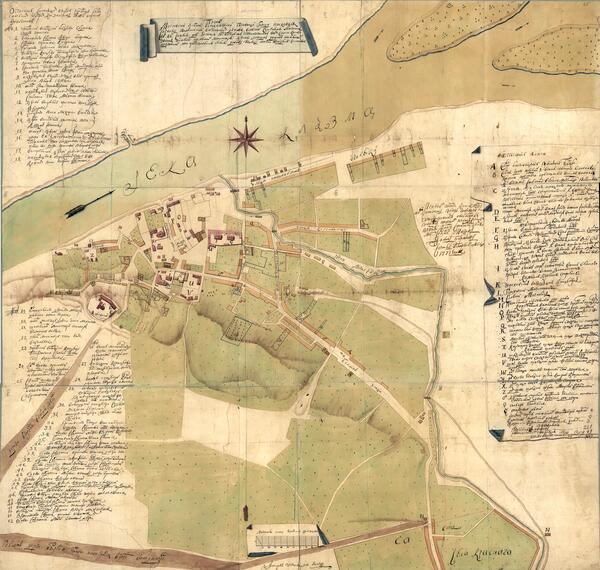
In the Russian State Archive of Ancient Acts, the fund called “Provincial, county and city atlases, maps and plans of the general land survey” has preserved two documents of this era, relating to Gorokhovets. One of them was compiled in 1771.
It shows civil and stone church buildings, and occasionally wooden ones, although they are mostly depicted in a schematic manner. The town center was positioned between the Annunciation Cathedral and the Church of the Resurrection. There started the main element of the planning — Bolshaya Street, which was part of the road to Nizhny Novgorod. All other streets were also oriented towards the town square, and roads radiated from it in all directions. This simple and convenient town plan is called radial, even though in Gorokhovets it is rather schematic since the town plan was created with the peculiarities of natural relief in mind.
The plan provides explanations for stone church and state buildings, as well as dwellings and privately-owned factories. This is a truly valuable source of local history, which made it possible to establish the original owners of many town structures. The town plan of 1771 was the earliest source of information about Gorokhovets householders.
Notes made in the margins shed light on the historical names of streets and settlements. Many of those were lost due to the later architectural transformations.
Most importantly, the plan provides a detailed description of the property of the most prominent merchants and commoners, as well as the employees of local administrative institutions. This information, including the clear boundaries of the structures, helped reconstruct the social topography of the 17th-century town.
Cartographic documents are the most visual source of information on the architectural and planning state of the town before it switched to regular planning in the era of classicism. The items date back to the second half of the 18th century.
In the Russian State Archive of Ancient Acts, the fund called “Provincial, county and city atlases, maps and plans of the general land survey” has preserved two documents of this era, relating to Gorokhovets. One of them was compiled in 1771.
It shows civil and stone church buildings, and occasionally wooden ones, although they are mostly depicted in a schematic manner. The town center was positioned between the Annunciation Cathedral and the Church of the Resurrection. There started the main element of the planning — Bolshaya Street, which was part of the road to Nizhny Novgorod. All other streets were also oriented towards the town square, and roads radiated from it in all directions. This simple and convenient town plan is called radial, even though in Gorokhovets it is rather schematic since the town plan was created with the peculiarities of natural relief in mind.
The plan provides explanations for stone church and state buildings, as well as dwellings and privately-owned factories. This is a truly valuable source of local history, which made it possible to establish the original owners of many town structures. The town plan of 1771 was the earliest source of information about Gorokhovets householders.
Notes made in the margins shed light on the historical names of streets and settlements. Many of those were lost due to the later architectural transformations.
Most importantly, the plan provides a detailed description of the property of the most prominent merchants and commoners, as well as the employees of local administrative institutions. This information, including the clear boundaries of the structures, helped reconstruct the social topography of the 17th-century town.