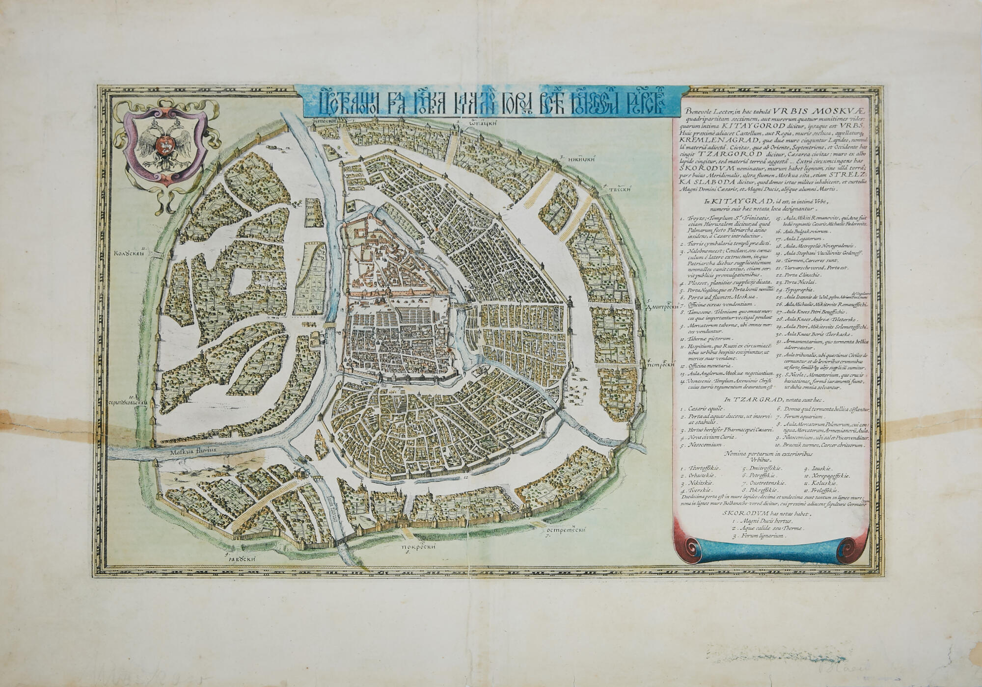
The Museum of Moscow presents a rare exhibit — the “Peter’s Map” of 1662 which is considered to be the earliest and most reliable plan of Moscow of the late 16th — early 17th centuries. The title of the plan is written in “vyaz” (Cyrillic calligraphy) “The Reigning City of Moscow, the Initial City of All of Moscow’s States”.
In Russia, this plan was unearthed quite late. The historian, ethnographer, folklore researcher, archaeologist and art critic Ivan Snegirev, named the plan “Peter’s Map” because he found it while digging through the personal papers of Peter I in 1837 in St. Petersburg. However, it was not the drawing itself that was found, but its engraved image on two sheets. The first one suggests that the sheet shows Moscow, and the second shows the Moscow Kremlin. There are two versions of the origin of this plan: it was brought by Peter I from Holland during the Great Embassy; or “Peter’s Map” could have arrived in Moscow earlier, together with the Dutch embassy of 1664–1665, which included the future mayor of Amsterdam Nicolaes Witsen, who was well-acquainted with the Russian tsar.
Materials for creating a plan of the capital accumulated for many decades. Long before the beginning of Boris Godunov’s reign, work began on measuring Moscow, primarily due to the active development of the city. In 1585, the construction of the walls and towers of the Bely Gorod began, and Fyodor Kon, who was in charge of these works, clearly could not do without drawings. Also, the repository of state documents received construction measurements and calculations after the construction of the walls and towers of the Wooden City. Moscow saw a great deal of construction during the reign of Boris Godunov. It was at this time that many new temples and stone chambers were built. In 1603, a new royal palace was built based on a special project. Thus, over time, there was plenty of material to create a plan of the capital. However, all of them were looted during the Time of Troubles and found their way to Holland. By order of the local publisher Hessel Gerritsz, the artists made copies of the drawing, and thus the well-known plan “Peter’s Map” appeared. The original documents, from the Moscow archives, were obviously lost.