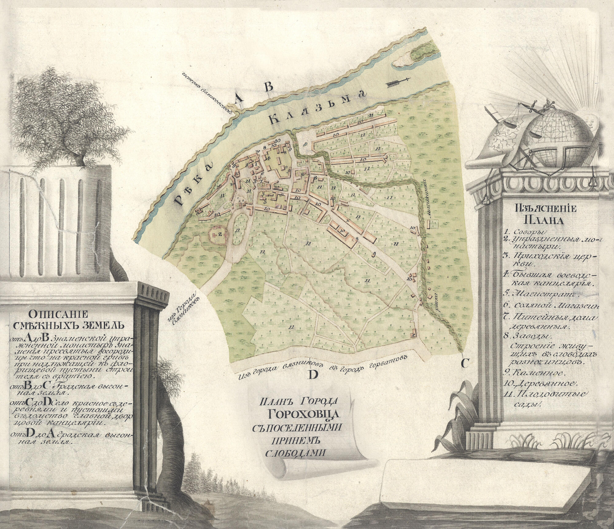


The urban map of Gorokhovets in the 1780s is the last image of the old town plan before the onset of great changes in the urban planning policy of the Russian Empire when towns moved from spontaneous development to regular planning and building strategies.
The plan on display mostly copies the plan of 1771 but provides less detail. It does not show the borders of private properties, and the legend does not provide elaborate explanations about the owners, only indicating church buildings and state institutions. The plan forgoes all excessive elements and highlights the main landmarks, making the chaotic nature of the old development more noticeable.
The planning structure of the town included two traditional parts: the early one (detinets) was located on Nikolskaya Gora, and the later one (posad) was down by the river. Unlike other ancient Russian towns, the kremlin (detinets) of Gorokhovets lost its original function of being the central part of the town early on — to the main square of the posad.
The posad had naturally formed borders, as it was developed with the peculiarities of the landscape in mind. In the west and the south, it was surrounded by a range of large hills —Nikolskaya Gora and Puzhalova Gora. In the north, the Klyazma River ran past the posad, and in the east — the small Mogilenka River.
The territory of the posad was shaped like a triangle gradually expanding from the west toward the east. The center was formed near the main town church — the Annunciation Cathedral. The town square was the center of all administrative offices. Important commercial establishments, such as a drysalter’s store and taverns, were also located there.
Conveyance across the Klyazma River was very significant for the town and had a designated place for it. Merchants paid not only ferriage but also a separate fare for transporting goods. It is no accident that the plan shows a customs office and the voivode’s chancellery near this place.
In general, the plan was created with minor changes to the natural landscape. The combination of plains, highlands, and floodplains created a truly picturesque scene, which is rare in other Russian towns.
The plan on display mostly copies the plan of 1771 but provides less detail. It does not show the borders of private properties, and the legend does not provide elaborate explanations about the owners, only indicating church buildings and state institutions. The plan forgoes all excessive elements and highlights the main landmarks, making the chaotic nature of the old development more noticeable.
The planning structure of the town included two traditional parts: the early one (detinets) was located on Nikolskaya Gora, and the later one (posad) was down by the river. Unlike other ancient Russian towns, the kremlin (detinets) of Gorokhovets lost its original function of being the central part of the town early on — to the main square of the posad.
The posad had naturally formed borders, as it was developed with the peculiarities of the landscape in mind. In the west and the south, it was surrounded by a range of large hills —Nikolskaya Gora and Puzhalova Gora. In the north, the Klyazma River ran past the posad, and in the east — the small Mogilenka River.
The territory of the posad was shaped like a triangle gradually expanding from the west toward the east. The center was formed near the main town church — the Annunciation Cathedral. The town square was the center of all administrative offices. Important commercial establishments, such as a drysalter’s store and taverns, were also located there.
Conveyance across the Klyazma River was very significant for the town and had a designated place for it. Merchants paid not only ferriage but also a separate fare for transporting goods. It is no accident that the plan shows a customs office and the voivode’s chancellery near this place.
In general, the plan was created with minor changes to the natural landscape. The combination of plains, highlands, and floodplains created a truly picturesque scene, which is rare in other Russian towns.