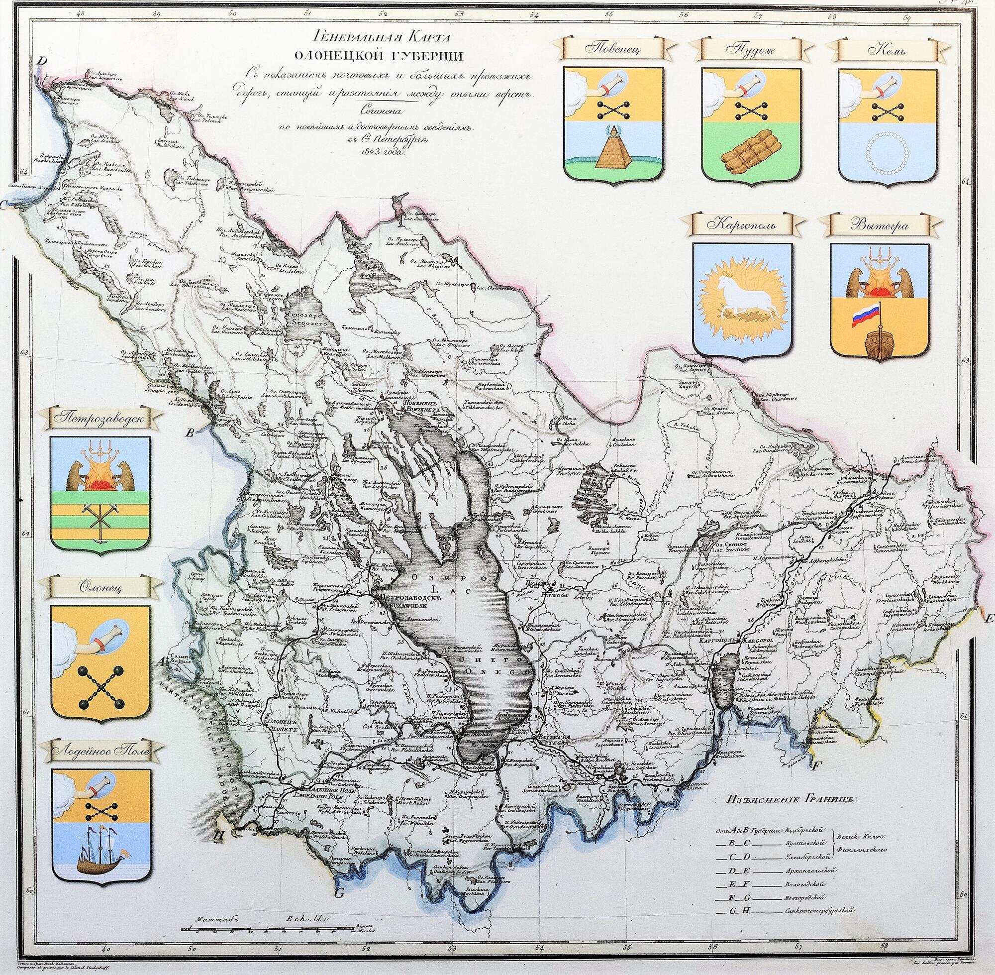
The Olonets governorate, the predecessor of Karelia, was marked on the map of the Russian Empire for almost 200 years. Its outline was significantly different from the modern Karelian republic. In the past, it included some territories that are now part of the Vologda and Arkhangelsk regions. Unlike the modern Karelia, the Olonets governorate did not have access to the White Sea.
For many decades, Olonets was the only city in the area. It gave the name to the entire territory: Olonia, Olonets uezd, Olonets province, Olonets governorate.
The governorate’s history as an administrative unit began in 1776 when Olonets uezd became a province in Novgorod Viceroyalty. In the 1770–80-s, new cities appeared on the region map: Vytegra, Petrozavodsk, Povenets, Kargopol, Lodeynoye Pole, Kem, Pudozh. The cities were granted coats of arms, sometimes they were marked on ancient maps. These cities became the uezd centers.
In 1781, Olonets was annexed to St. Petersburg governorate, and three years later, its status became higher — Olonets Viceroyalty was created and received the rights of a province. The capital was moved from Olonets to Petrozavodsk in 1784. The Olonets coat of arms was transferred to Petrozavodsk. It is an image of a hand with a shield (a symbol of protecting the borders) and bar shots that are crossed, and sea projectiles. The bar shots were naval artillery shells in the days of sailing boats. The shell consisted of two massive cast-iron details connected by an iron rod or chain.
Emperor Paul I abolished the viceroyalty in 1796 and annexed the Olonets lands to Novgorod, and Alexander I restored the former governorate status in 1801. It existed until 1922.
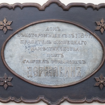
The map of the Olonets province is on view in the section of the permanent exhibition “By the Highest Decree. The Foundation of the Olonets Governorate in the late 18th — early 19th centuries.” The exhibition is located in a two-level hall that displays the architecture of the building — a fragment of the wall and foundation of the late 18th century. Here one can see objects and documentary materials related to the creation of the governorate cities, the development of Petrozavodsk, the first governor Gavriil Derzhavin, as well as archaeological finds discovered on the territory of the museum building — the former governor’s house.
For many decades, Olonets was the only city in the area. It gave the name to the entire territory: Olonia, Olonets uezd, Olonets province, Olonets governorate.
The governorate’s history as an administrative unit began in 1776 when Olonets uezd became a province in Novgorod Viceroyalty. In the 1770–80-s, new cities appeared on the region map: Vytegra, Petrozavodsk, Povenets, Kargopol, Lodeynoye Pole, Kem, Pudozh. The cities were granted coats of arms, sometimes they were marked on ancient maps. These cities became the uezd centers.
In 1781, Olonets was annexed to St. Petersburg governorate, and three years later, its status became higher — Olonets Viceroyalty was created and received the rights of a province. The capital was moved from Olonets to Petrozavodsk in 1784. The Olonets coat of arms was transferred to Petrozavodsk. It is an image of a hand with a shield (a symbol of protecting the borders) and bar shots that are crossed, and sea projectiles. The bar shots were naval artillery shells in the days of sailing boats. The shell consisted of two massive cast-iron details connected by an iron rod or chain.
Emperor Paul I abolished the viceroyalty in 1796 and annexed the Olonets lands to Novgorod, and Alexander I restored the former governorate status in 1801. It existed until 1922.
The map of the Olonets province is on view in the section of the permanent exhibition “By the Highest Decree. The Foundation of the Olonets Governorate in the late 18th — early 19th centuries.” The exhibition is located in a two-level hall that displays the architecture of the building — a fragment of the wall and foundation of the late 18th century. Here one can see objects and documentary materials related to the creation of the governorate cities, the development of Petrozavodsk, the first governor Gavriil Derzhavin, as well as archaeological finds discovered on the territory of the museum building — the former governor’s house.