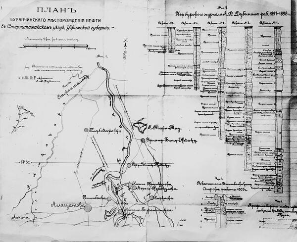
During the second half of the 19th century, the oil industry began rapidly developing throughout the world. This led to an increased interest of scientists and local entrepreneurs in the Ural and Volga region: they already were aware of the presence of oil in this area, however no one knew whether there were sufficient quantities for its production. This map is a valuable document relating to Tsarist-era oil exploration in what would later become the Volga and Ural oil and gas region. It was compiled by mayor of Sterlitamak A.F. DubInin in the 1890s. The map shows the survey locations near the village of BurAnchino, which neighbored the village of Ishimbaevo.
The first surveys in this region began much earlier. In 1863, the scientific committee of the Corps of Mining Engineers tasked the famous professor and scientist Gennady Romanovsky to conduct a geological study of the Volga region in order to determine its prospects for oil exploration. During the first geological studies of the region he was joined by the first director of the Geological Committee of Russia Grigory Gelmersen and scientist Pavel Eremeev. In his assessment of the oil-bearing capacity of the Ural and Volga region, Romanovsky wrote: ‘The Permian sediments do not contain the bulk of local oil reserves, and the oil found there may only serve to indicate the presence of rich underground deposits.’ In 1868, he suggested that ‘oil sources should appear in the Devonian sediments. . . at a depth of at least 100 sazhens (more than 200 meters).’ The scientist’s assumptions regarding the presence of large Devonian oil deposits in the Ural and Volga region were confirmed 75 years later, although his estimates of their depth of occurrence were off.
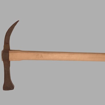
The first geological study of the territories included in the present-day Ishimbay region was carried out by Valerian Meller, a geologist working for the Mining Department of Russia, between 1880 and 1881. Even though he gave a negative assessment of the oil-bearing capacity of this area, he left the most complete description of oil seepages around the village of Ishimbaevo of the Sterlitamak District. Before that, entrepreneurs searched this land for minerals. Between 1864–1867, mining engineer A.K. Vasiliev drilled a 32-meter-deep well in the vicinity of the villages of Yar-Bishkadak and Urman-Bishkadak, which are located on the territory of the present-day Ishimbay region. The project was carried out by order of the Orenburg Governor-General for the purposes of oil and coal exploration and at the expense of the treasury. Vasiliev also excavated a 106-meter-long adit and three mines ranging between 10 and 45 meters in depth but found nothing but asphalt, a type of black mineral pitch.
In 1880, entrepreneurs Nekerov and Popov conducted shallow oil exploration near the village of Nizhne-Buranchino in the vicinity of Ishimbaevo, on land leased to them by the Bashkirs. They were convinced of the presence of oil at great depths; however, their search yielded no results. Between 1911 and 1914, A.I. Sroslov drilled 5 wells ranging between 27 and 100 meters in depth near Ishimbaevo. Even one of Alfred Nobel’s companies showed interest in these lands during World War I. In 1916, the geologist A.P. Zamyatin put an end to the Tsarist-era chapter in the history of oil exploration. Having examined the area, he concluded that there was no commercial oil to be found here.
The first surveys in this region began much earlier. In 1863, the scientific committee of the Corps of Mining Engineers tasked the famous professor and scientist Gennady Romanovsky to conduct a geological study of the Volga region in order to determine its prospects for oil exploration. During the first geological studies of the region he was joined by the first director of the Geological Committee of Russia Grigory Gelmersen and scientist Pavel Eremeev. In his assessment of the oil-bearing capacity of the Ural and Volga region, Romanovsky wrote: ‘The Permian sediments do not contain the bulk of local oil reserves, and the oil found there may only serve to indicate the presence of rich underground deposits.’ In 1868, he suggested that ‘oil sources should appear in the Devonian sediments. . . at a depth of at least 100 sazhens (more than 200 meters).’ The scientist’s assumptions regarding the presence of large Devonian oil deposits in the Ural and Volga region were confirmed 75 years later, although his estimates of their depth of occurrence were off.
The first geological study of the territories included in the present-day Ishimbay region was carried out by Valerian Meller, a geologist working for the Mining Department of Russia, between 1880 and 1881. Even though he gave a negative assessment of the oil-bearing capacity of this area, he left the most complete description of oil seepages around the village of Ishimbaevo of the Sterlitamak District. Before that, entrepreneurs searched this land for minerals. Between 1864–1867, mining engineer A.K. Vasiliev drilled a 32-meter-deep well in the vicinity of the villages of Yar-Bishkadak and Urman-Bishkadak, which are located on the territory of the present-day Ishimbay region. The project was carried out by order of the Orenburg Governor-General for the purposes of oil and coal exploration and at the expense of the treasury. Vasiliev also excavated a 106-meter-long adit and three mines ranging between 10 and 45 meters in depth but found nothing but asphalt, a type of black mineral pitch.
In 1880, entrepreneurs Nekerov and Popov conducted shallow oil exploration near the village of Nizhne-Buranchino in the vicinity of Ishimbaevo, on land leased to them by the Bashkirs. They were convinced of the presence of oil at great depths; however, their search yielded no results. Between 1911 and 1914, A.I. Sroslov drilled 5 wells ranging between 27 and 100 meters in depth near Ishimbaevo. Even one of Alfred Nobel’s companies showed interest in these lands during World War I. In 1916, the geologist A.P. Zamyatin put an end to the Tsarist-era chapter in the history of oil exploration. Having examined the area, he concluded that there was no commercial oil to be found here.