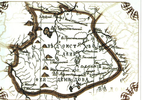
The map shows the boundaries of “Akinfiy Demidov’s Department” — a huge territory, comparable in size to some European countries. This “mountain kingdom” was a vast and continuously expanding economic formation. New territories were annexed to it. It was not the land itself that was valuable, but rather its industrial potential: ore deposits, quarries, rivers, which were transport routes and sources of energy, forests, which provided construction wood and fuel for the blast furnace (charcoal), and territories for building factories.
The creation of the Demidov mining “department” began with the construction of the Nevyansk plant, which in 1702 was granted by Peter I to the Tula blacksmith Nikita Demidovich Demidov (Antyufeyev). After the Nevyansk plant, Nikita and his son Akinfiy began building other factories in the Urals.
The main part of the Ural factories belonging to Akinfiy Demidov formed a compact group, largely interconnected by production (cast iron was delivered from blast furnace factories to iron factories). Located on a vast territory around and to the west of Nevyansk and Nizhny Tagil, they were the “department of Akinfiy Demidov” both in terms of production and administration. On the land map of 1734–36, the “department” includes the territories along the Tagil, Neiva, and Chusovaya Rivers.
Demidov’s “department”, like a real state, had its own subjects, laws, troops, a flotilla of ships, fortresses with cannons and a “capital” — the Nevyansk plant. Settlements and factories were connected to each other by excellent roads, ensuring mutually beneficial cooperation: peasants used the roads to carry “grain supplies” to the factories and iron products needed in agricultural production back home.
The owner of the factories, Akinfiy Demidov, was free from the supervision of local authorities. By the decree of Elizaveta Petrovna as of April 27, 1744, not a single issue concerning Akinfiy Demidov could be resolved without the knowledge of the empress.
After Akinfiy Demidov’s death, a huge industrial power remained, including 25 iron and copper factories with 123 blast furnace, hammer and other factories, 25 dams, 85 iron and copper mines, 3 piers, and a huge river fleet. In 215 towns and villages, not counting factory settlements, there were 13,135 male serfs. In addition, there remained 120 houses and courtyards with stone and wooden mansions and all other house buildings, with vegetable gardens, ponds, and cattle yards.