Шрифт
Цвет
Графика
Изображение точки

To see AR mode in action:

1. Install ARTEFACT app for iOS or Android;

2. Find the exhibition «From Tsarist Russia to the Yalta Conference»

3. Push the «Augmented reality» button and point your phone's camera at the exhibit;

Скрыть точки интересаПоказать точки интереса
Показать в высоком качестве

Topological Map of Southern State Railroads

Creation period
1912
Place of сreation
the Russian Empire
Dimensions
37x22,5 cm
Technique
letterpress printing, ink, handwriting, gilding
0
Open in app
#7
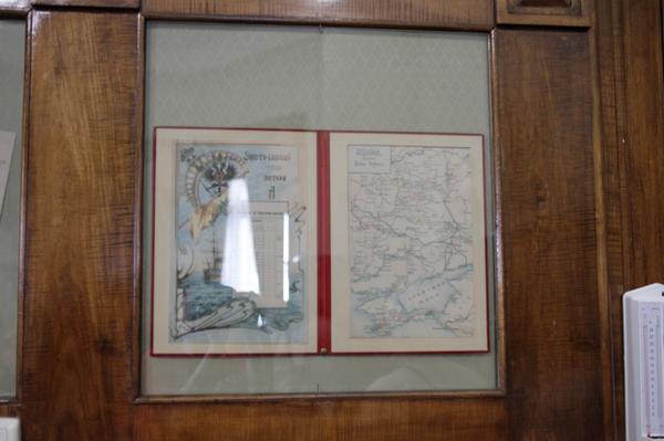
The exhibition in the study of Emperor Nicholas II presents an album with the topological map of Southern State railroads. On the left-hand page of the spread, inside an Art Nouveau frame is a picture with a Double-Headed Eagle at the top encircled by a crescent moon and a flag.

The development of railroads in Russia began during the reign of Emperor Nicholas I. Under Emperor Alexander II, in the second half of the 19th century, the railroad network throughout the Empire saw rapid expansion. This development was also facilitated by regular trips of Empress Maria Alexandrovna to Livadia — her favorite residence on the Southern coast of Crimea where she went to take care of her health. Suffering from tuberculosis, the Empress needed the most comfortable form of transport — rail or sea.

At the beginning of March 1868, the mayor of Kharkiv, M. Shatunov, received a telegram from St. Petersburg that read:
#8
Our petition was successful. The Supreme Decree on the construction of the Kursk–Kharkiv–Azov railroad has been approved. The construction is expected to be launched simultaneously along the entire path. My congratulations to the city!
#9
It was then decided to build a railroad. The construction began in May 1868 with the Belgorod–Kharkiv section.

By May 1869 — in just one year — Kharkiv residents welcomed their first train. Regular transit on the Kursk–Belgorod–Kharkiv track that stretched 229 versts (approx. 244.3 km) began in July 1869, and before the end of that same year, the track from Kharkiv to Rostov that spanned 538 versts (approx. 574 km) was added.

The end of the XIX century was marked by a real boom in railroad construction in the Slobozhanshchyna region. Right after Kursk–Kharkiv–Azov, the Kharkiv–Mykolaiv and the Lozovo–Sevastopol railroad tracks opened their lines. Since 1896, the track’s name was changed to the Kursk–Kharkiv–Sevastopol track, and from January 1, 1907, on the basis of a corresponding government decree, the Kursk–Kharkiv–Sevastopol and Kharkiv–Mykolaiv railroads were combined into a network under the common name Southern Railroads.
#6
Посмотреть в Госкаталоге
read morehide
00:00
00:00
1x

Topological Map of Southern State Railroads

Creation period
1912
Place of сreation
the Russian Empire
Dimensions
37x22,5 cm
Technique
letterpress printing, ink, handwriting, gilding
0
Point your smartphone camera to open in the app
Share
VkontakteOdnoklassnikiTelegram
Share on my website
Copy linkCopied
Copy
Open in app
To see AR mode in action:
  1. Install ARTEFACT app for 
  2. iOS or Android;
  3. Find and download the «Paintings in Details» exhibition
  4. Push the «Augmented reality» button and point your phone's camera at the painting;
  5. Watch what happens on your phone screen whilst you flip through the pictures.
 
We use Cookies
Cookies on the Artefact Website. We use cookies to ensure that we give you the best experience on our website. If you continue without changing your settings, we'll assume that you are happy to receive all cookies on the Artefact website. However, if you would like to, you can change your cookie settings at any time.
Подробнее об использованииСкрыть
Content is available only in Russian
%title%%type%